Rio de Janeiro Maps and Orientation
(Rio de Janeiro, Brazil)
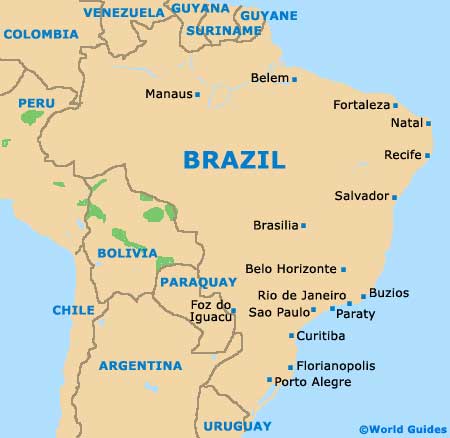
Located on the south easterly coastline of
Brazil (
Brasilia) and next to the Atlantic Ocean, Rio stands within the state of Rio de Janeiro, where it serves as the capital. The population of Rio de Janeiro is currently around seven million, although more than 13 million people now reside within the enormous metropolitan area.
The city itself comprises two main regions, known as the North Zone (Zona Norte) and the South Zone (Zona Sul). The North Zone of Rio de Janeiro is made up of mainly working-class neighbourhoods and large, industrial areas, while the South Zone is home to the many tourist attractions, hotels and the most popular beaches.
Maps and Orientation of the City
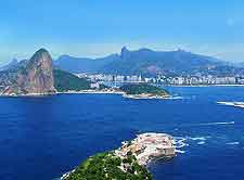
Central Rio de Janeiro is generally referred to as the Centro and incorporates the Santa Teresa area. Centro is an important business district and the actual original spot of the earliest settlement. This part of the city contains a number of Riotur tourist outlets, where maps of Rio are available, with the Riotur Centro being situated on the Rua Assembleia.
On the southerly side of Centro are the suburbs of Botafogo, Catete, Flamengo, Gloria, Lapa and Urca, the latter of which is somewhat dominated by the dramatic peak of the
Sugarloaf Mountain (Pao de Açúcar). Head a little further to the south of central Rio de Janeiro and you will soon encounter the enticing tourist hotspots of Copacabana, Ipanema and also Leblon. Tourists holiday in Rio de Janeiro will most likely find themselves sightseeing between the Atlantic Ocean coastline and the very scenic Guanabara Bay (Baia de Guanabara).
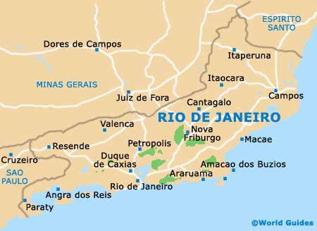
- Armacao dos Buzios - 169 km / 105 miles (two hours and five minutes, north-east)
- Araruama - 111 km / 69 miles (one hour and 40 minutes, east)
- Barbacena - 272 km / 169 miles (three hours and 20 minutes, north)
- Cachoeiras de Macacu - 94 km / 58 miles (one hour and 25 minutes, east)
- Caraguatatuba - 377 km / 234 miles (four hours and 50 minutes, south-west)
- Grumari - 47 km / 29 miles (50 minutes, south-west)
- Juiz de Fora - 178 km / 111 miles (two hours and 15 minutes, north)
- Macae - 184 km / 114 miles (two hours and 25 minutes, north-east)
- Niteroi - 16 km / 10 miles (20 minutes, east)
- Nova Friburgo - 133 km / 83 miles (two hours and five minutes, north-east)
- Nova Iguacu - 36 km / 22 miles (35 minutes, north-west)
- Paraty - 254 km / 158 miles (three hours and 30 minutes, west)
- Petrópolis - 64 km / 40 miles (one hour and five minutes, north)
- Pouso Alegre - 371 km / 231 miles (four hours and 45 minutes, north-west)
- Santos - 502 km / 312 miles (six hours and 20 minutes, south-west)
- Sao Jose dos Campos - 340 km / 211 miles (four hours and 20 minutes, west)
- Sao Lourenco - 271 km / 168 miles (three hours and 15 minutes, north-west)
- Sao Paulo - 441 km / 274 miles (five hours and 25 minutes, south-west)
- Teresopolis - 95 km / 59 miles (one hours and 25 minutes, north)
- Tres Rios - 125 km / 78 miles (one hour and 45 minutes, north)
Map of Brazil
Map of Rio de Janeiro State
Map of Rio de Janeiro

